Hakalau Forest National Wildlife Refuge
The U.S. Fish & Wildlife Service maintains the Hakalau Forest National Wildlife Refuge, located approximately 12 miles to the north of mile marker 28 on Saddle Road. While the main portion of the refuge is generally closed to the public, the northernmost section, the Maulua Unit, is open weekends and holidays. Every visitor requires a reservation which may be obtained by contacting the Hakalau Forests NWR offices at (808) 443-2300, 8 AM – 4 PM, Monday-Friday. A link to the reservations page is HERE. Additional descriptions of the Hakalau Refuge (a lovely color brochure), Public access to the Upper Maulua unit (B/W folded 2 page brochure) and a short list of “Birding Hot Spots” for the Big Island (3 page xerox with approximate map locations) can be obtained at the office or by having them mailed to the requester. Both brochures talk about caution when driving on the Maulua Unit 4WD road. The distance from the gate to the car park is 2.9-3.0 miles down a 1000′ total drop with occasional steep drop-offs to both sides of the road. Caution is recommended.
In early September the invasive banana poka is in full bloom as well as the orange ohia lehua. During my last trip (9/3/2006) I saw literally many dozens of apapane and i’iwi feeding on both types of blossoms. I also saw elepaio, oma’o, red-billed leiothrix and amakihi frisking about in the understory. It was a good day.
The drive to Maulua is ~45 miles from Hilo, with the first 30 being on pavement (mostly Saddle Road) and the remaining ~15 miles on a bone-jarring, marginally-kept, 4WD dirt road with steep drop-offs near the road shoulder in some sections. When rain and clouds roll in – sometimes within 10-20 minutes – driving can be dangerous and considerable caution is recommended.
In dry weather, 4WD is optional but rainy conditions would make it a necessity. I have only driven Mana/Keanakolu road in my ’99 Toyota SR5 4Runner in good conditions – and then needing only the H4 gear setting to feel in control of the road. I honestly don’t think I’d try it under rainy, muddy conditions.
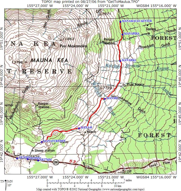
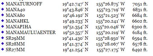
Getting to Maulua Topographic Map – a half page sheet of directions for getting to Maulua should be obtained from the above source. What follows are general maps from the Mauna Kea access road turnoff onto Mana/Keanakolu Road to the Maulua Gate adjacent to the Nobriga Ranch. On a clear day, there are beautiful views of Hilo and Mauna Loa along the road. I have noted GPS locations approximately every 4 miles. The waypoint MANAHKL marks the entrance to the Hakalau Forest Research area. MANAPIHA marks the Piha section of the area, and MANAMAULUAENTER marks the Maulua Gate location. Mana / Keanakolu Road continues through to Waimea town. Experienced 4WD-ers suggest that the road is passable with no problems, but beginners such as myself have reservations regarding such descriptions. On my most recent trip (9/3/2006) ATV riders traveling at high speed in the opposite direction made for a serious near miss situation. During normal weekends, this might not be such a problem.
Getting to Maulua
Get to Maulua GPS Data
Get To Maulua Elevation Data
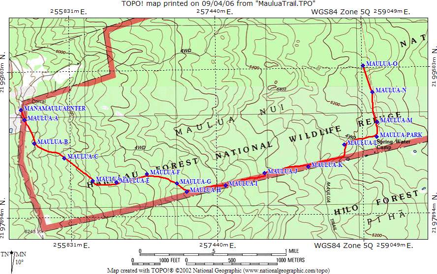
Maulua Trail Topographic Map – Much if not all of this area was devoted to cattle ranching for a considerable length of time. This means that cattle, along with goats and pigs, either eliminated did considerable damage to the forest understory resulting in pasture land with relatively few but large koa and ohia trees as well as a scattering of mamane and naio. Such a landscape occupies the first mile or so of trail. Here I recently first heard a Hawaiian hawk (‘io) give its hunting scream, soaring at a height of several hundred feet above me. Tremble, ‘iole!
Panorama Views – Former pastures with old koa trees – about 1/3 of the way down the trail.
As the forest begins to close in, more birds appear as well as different types of ferns and additional trees and understory. On one visit (8/28/2006) there were many oma’o, i’iwi and amakihi in the upper portions of the trail.
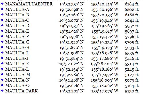
Maulua Trail GPS Data
Maulua Trail elevation Data – from top to bottom, this is ~ 1000′ elevation drop. If you have the choice, 4WD is much more convenient, especially on the return trip.


