Fishing Weather Prediction
Off Windward Big Island…
Unlike Kona where winds can suddenly come from nowhere and make biminis a recent memory, windward Big Island weather is generally more predictable. In my limited experience, bad weather can be seen some distance off and there’s usually sufficient time for an orderly retreat. I’ll admit from the first that with my small boat and preferences for bottom fishing and jigging as compared with trolling, I prefer calmer seas.
With the advent of NOAA’s extensive weather forecasting presentations on the Internet, we can also try to look from several days to as much as a week into the future to see what type of weather is brewing. Today’s cyber fisherman are blessed with a plethora of weather forecasting and nearly-real-time observation sites.
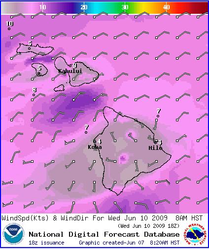
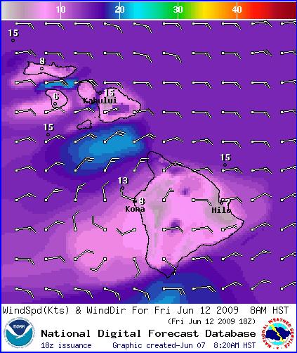
When I’m thinking about going fishing sometime in the next few days, I generally look at wind speed and direction predictions first. This NOAA website gives graphical representations of Wind Speed and Direction. The page begins with temperatures; use the pull down table to choose winds. These wind speeds and directions are important because in addition to local rain showers at sea, they give a sense of how high the wind waves might be because these winds are also directly connected to the water. Such information is important for comfort and safety. For example if I see 10-15 mph trades blowing steadily, I personally might not want to go farther east than 6-mile (from Hilo) or north than Pepeekeo; others with larger craft might feel that this was just the beginning of interesting trolling weather!
The picture below left (with its forecast below) looks to be O.K. for me at least for any point to point activities. It might be a little lumpy between 6-mile and Keaau Bay, but overall an ono run might be possible for me. The picture below right would definitely be a bigger boat day as far as I’m concerned, especially with 5′ wind waves. In both cases, note the wind “shadow” on the lower half of the Kona side, and the higher than average winds in the Alenuihaha channel between Maui and the Big Island.
 |
 |
Another useful NOAA website gives Wave Height and ( sort of )Direction. In the winter when great storms generate sizeable swell from thousands of miles away, this website shows the direction, size and progression of these great wave trains many days in advance. Another site gives current direction and speed.
For non-graphical presentation of forecast wind speed and direction as well as wind waves and swell over a 5-day period, the Big Island Windward Waters Forecast is also quite useful.
On the morning of a given fishing day, I always check the NWS (National Weather Service) radar loop from South shore Hawaii (Doppler Radar). This website shows rain shower size and direction of movement during the previous hour’s time. The winds moving these rain showers are sometimes much higher in altitude than local surface winds. It’s not uncommon to have local surface winds and winds moving rain showers in opposition or at least right angles to one another. Since rain showers often generate wind waves locally that last for an hour or more as a result of the downward then lateral movement of the air carried by the rain , this Doppler radar information can give you a sense of local sea conditions in a particular area. Lots of pocket showers will often make for a very lumpy sea.
You can also roughly estimate the over the water speed of the rain showers. On my screen showing the Big Island, 1″ on the map is a distance of ~ 45 miles. The loop length on the screen is 45 minutes or 0.75 hours. So if the rain cloud moved 1″ on the screen (45 miles) in 0.75 hours, then it would move ~ 60 miles in 1 hour. To obtain the rain shower speed estimate, just multiply the measured distance moved during the loop in decimal inches times 60. For example, a distance of 1/4″ (0.25 “) would equate to 0.25 X 60 = 15 mph.
I like those days when it’s safe and comfortable to go to the FADS. But each FAD has a particular scope or amount of slack line that allows the buoy to move somewhat in the direction of prevailing currents. This means that a cloud of points is necessary to describe where the buoy will be from time to time. But if you know the general sea surface current direction (as shown by the arrows), then you know which side of the cloud of points to search in order to find the buoy. A Naval Oceanographic Office website shows Sea Surface Height and Ocean Current Speed and Direction. See my FAD Data page for more details about using this website for finding the FADS.
Although the tides aren’t part of the winds, waves and swell, their change can sometimes affect local currents and surely have an effect on whether fish are in the mood or not. A wonderful free software program is WXTIDE32. This is a great program, easily customizable and takes up very little space on your computer. Below are two screen shots of most of the settings I use for this program:
Add two picture table…